Bengaluru, once celebrated as India’s Silicon Valley and a city of pleasant weather, is facing an increasingly urgent question that shapes real estate decisions like never before: “Does this area flood?” Rapid urban growth, coupled with climate unpredictability and stretched infrastructure, has transformed flooding from a rare inconvenience to a regular threat. For buyers, investors, and developers, understanding flood risk is no longer optional—it has become a critical factor that can determine property value, safety, and long-term livability.
Present State
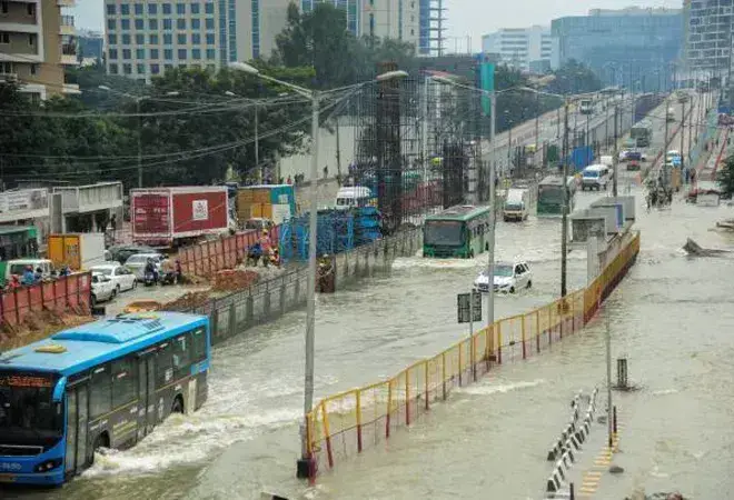
Bengaluru received over 100 mm of rainfall on 19th May, the highest single-day pre-monsoon downpour since 2011, leading to severe flooding across key residential and commercial zones. The deluge claimed three lives, including that of a 12-year-old boy and a 35-year-old IT professional, and forced major tech companies to shift to work-from-home arrangements. At least 210 flood-prone zones have been identified by the city corporation, with water entering homes, submerging vehicles, and overwhelming key IT corridors such as Outer Ring Road and Whitefield.
Despite being a major tax contributor, Bengaluru continues to face annual monsoon chaos, with experts attributing it to rapid urbanization, shrinking lakes, and poor drainage infrastructure. The opposition has demanded an immediate relief fund of ₹1,000 crore (approx. $117 million), while the government blames decades of mismanagement across multiple regimes. With more rain forecast due to cyclonic activity in the Andaman Sea, the crisis has reignited debate over the city's fragile planning and the need for urgent long-term infrastructure reform.
Urban Flooding History
The monsoon season of 2024 brought Bengaluru 36% excess rainfall compared to the long-term average, according to the Indian Meteorological Department. The deluge resulted in severe waterlogging in over 110 localities, including prominent areas such as Sarjapur, Marathahalli, Bellandur, Yemlur, Whitefield, and even upscale sections of the Outer Ring Road.
A study by the Indian Institute of Science revealed that 79% of flood-affected areas in Bengaluru were built on former lake beds or natural stormwater channels. Over the past five decades, the city’s built-up area has surged from 16% in 1973 to more than 93% by 2020, with green cover and natural water retention areas shrinking significantly. This unchecked urbanization has disrupted natural drainage and increased flood vulnerability.
Changing Buyer Priorities: Flood Risk Takes Center Stage
Recent floods have dramatically shifted homebuyer priorities. For NRIs and tech industry professionals, flood risk now often trumps traditional factors such as amenities or developer reputation. Local brokers report that inquiries for properties in flood-prone zones have dropped by up to 20% since mid-2024.
Micro-markets like Mysuru Road, Kengeri, HSR Layout, and Hennur Road have experienced fewer site visits and longer sales cycles despite competitive pricing. The “location premium” once associated with proximity to tech hubs is now challenged by concerns over flooding, forcing developers to rethink their strategies.
The City’s Altered Terrain: Lakes, Valleys, and Vanishing Drainage
Bengaluru was originally built across three major valley systems—Hebbal, Vrishabhavathi, and Koramangala-Challaghatta—with over 200 interconnected lakes acting as a natural flood control system. However, urban growth has led to the filling or fragmentation of many lakes, and the Environmental Management & Policy Research Institute (EMPRI) reports that nearly 65% of stormwater drains are either encroached upon or choked.
Despite the leveling of land for construction, water during heavy rains continues to follow the original natural courses, resulting in flash floods and waterlogging in newly developed or reclaimed areas.
Infrastructure Lagging Behind Development
While satellite townships such as Devanahalli, Thanisandra, and parts of North Bengaluru are seeing rapid real estate growth, civic infrastructure has not kept pace. Master plans often still classify these areas as green or agricultural zones, but they are now dotted with high-rise developments lacking adequate stormwater and sewage systems.
The Bruhat Bengaluru Mahanagara Palike (BBMP) has acknowledged that over 1,500 km of stormwater drains need urgent desilting, upgrading, or rerouting. Without infrastructure improvements aligned with development, new and old areas remain equally vulnerable to flooding.
Real Estate Market Trends: Numbers Reveal a Mixed Picture
Despite the challenges, Bengaluru’s housing market showed resilience with a 10% year-on-year increase in housing sales in Q1 2025 (Knight Frank). However, this growth masks distinct disparities:
- Flood-prone localities witnessed a 12–15% drop in buyer inquiries and secondary market transactions.
- Price appreciation in these high-risk zones slowed to under 3% YoY, compared to 6–7% in safer northern suburbs like Hebbal and Jakkur.
Ass per The Hindu, In Northwood (Yelahanka), post-flooding, properties previously valued around ₹2.5 crore are reportedly struggling to sell even at ₹2 crore.
What Buyers Are Checking Now: A More Rigorous Due Diligence
Homebuyers and investors are now employing more sophisticated research tools and strategies, including:
- Satellite Imagery & Terrain Analysis: Using Google Earth, Bhuvan (ISRO), and other platforms to detect historic marshlands, lake beds, and disrupted drainage channels.
- Village & Survey Maps: Accessing land records via Karnataka’s Bhoomi portal to check for former tanks, streams, and natural watercourses.
- Zoning Compliance Checks: Verifying that properties are not built over catchment areas or “rajakaluves” (natural drains), which face legal and flood risks.
- Flood Records and Alerts: Consulting IMD flood zone maps and news archives for past flooding events.
- RERA Registration: Ensuring the project complies with legal norms and is backed by regulatory safeguards.
Developers’ Response: Partial Adaptation and Emerging Practices
Some developers have begun to integrate flood mitigation measures such as:
- Rainwater harvesting systems
- Elevated building foundations
- Pumped drainage solutions
Certain projects now offer flood risk certificates or hydrological audits to reassure buyers. However, the Confederation of Real Estate Developers' Associations of India (CREDAI) reports that only 20% of developers conduct formal flood risk assessments prior to construction, highlighting significant room for improvement.
A Call for Systemic Urban Policy Reform
Experts stress that Bengaluru must reverse its current development model, where real estate growth outpaces infrastructure provisioning. Sustainable urban planning would mandate:
- Pre-development hydrological and environmental impact studies
- Strict enforcement of zoning and land-use laws
- Simultaneous upgrading of stormwater drainage alongside new construction
- Restoration and reconnection of lake systems and natural drains
The proposed Greater Bengaluru Governance Bill, if enacted, promises to unify civic agencies, enhancing infrastructure planning and enforcement to better manage flooding risks.
A Simple Question with Serious Implications
Flooding in Bengaluru has evolved beyond an environmental challenge into a defining factor of its real estate market. As the city continues to expand, ignoring flood risks could mean facing costly damages and dwindling demand. Sustainable growth demands that infrastructure planning takes precedence over unchecked development, ensuring that future Bengaluru remains resilient and livable. In this changing landscape, the question “Does this land flood?” is no longer just about weather—it’s about safeguarding investments, communities, and the city’s future.
Image source- orfonline.org


.png)