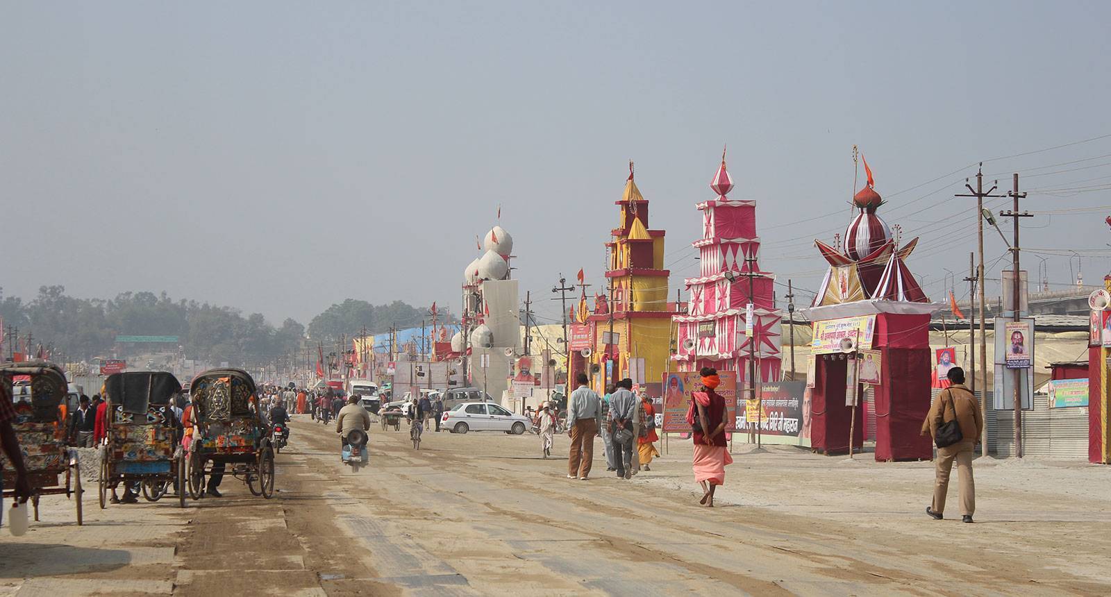
The Indian Space Research Organisation (ISRO) has released striking satellite images that give us a bird's-eye view of the ongoing transformations taking place in Prayagraj for the Maha Kumbh Mela 2025. The Maha Kumbh Mela, which is the world's largest religious gathering, is currently underway, attracting millions of pilgrims, sadhus, and tourists from all over the world.
To accommodate such a massive influx of people, the Uttar Pradesh government has embarked on a series of extensive infrastructure projects, many of which are clearly visible through the satellite images captured by ISRO’s EOS-04 (RISAT-1A) satellite. These images not only show the scale of the preparations but also highlight the ongoing efforts to ensure the smooth and safe functioning of this grand event.
A View from Space: Maha Kumbh’s Transformation
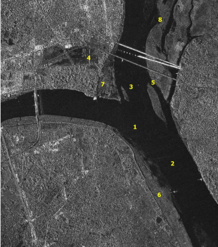
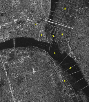
Source: nrsc.gov.in
- 1 - Triveni Sangam
- 2 and 3 - Pontoon Bridges
- 4 - Parking, Medical Facilities etc. at Parade Ground
- 5, 6, 7 and 8 - Tent City Infrastructure
The Maha Kumbh Mela, held every 12 years, attracts millions of pilgrims, sadhus, and tourists from across the globe. To accommodate this massive influx, the Uttar Pradesh government has undertaken extensive infrastructure projects, many of which are visible from space. The latest satellite images reveal large-scale developments at the Triveni Sangam, Shivalay Park, and the Parade Grounds.
One of the most striking transformations seen in the satellite imagery is the expansion of the Kumbh Mela area. The festival ground has been expanded to cover over 4,000 hectares, a 25% increase from the previous Kumbh Mela in 2019. This expansion aims to ensure better crowd management and accessibility for the millions of devotees expected to attend.
ISRO's Satellite Images: A Glimpse into the Transformation
ISRO's time-series satellite images, captured on September 15, 2023, and December 29, 2024, offer a striking comparison of how Prayagraj has evolved to host this mega event. These images were taken using the EOS-04 (RISAT-1A) 'C' band microwave satellite, which has all-weather capability and high-resolution imaging power. The images reveal key developments, including:
Tent City Layout
The satellite images clearly depict the large-scale setup of the Tent City, which houses thousands of temporary shelters for pilgrims. The layout, including roads, sanitation facilities, and essential services, has been strategically designed to ensure a smooth experience for visitors.
Pontoon Bridges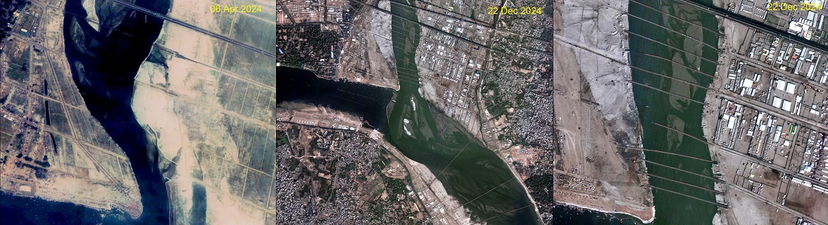
Source: nrsc.gov.in
To facilitate easy movement across the riverbanks, multiple temporary pontoon bridges have been constructed over the Ganges. The satellite images showcase the expansion of these floating bridges over time, enabling pilgrims to access different ghats safely.
Shivalay Park 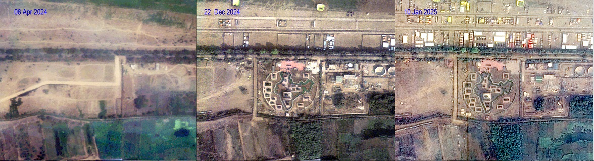
Source: nrsc.gov.in
One of the highlights of Maha Kumbh 2025 is the newly constructed Shivalay Park, a 12-acre park shaped like the map of India. The park serves as a cultural and spiritual landmark, offering a place for meditation and religious gatherings. The satellite images document the gradual development of this landmark, emphasizing its importance to the event.
Parade Grounds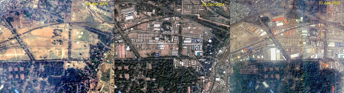
Source: nrsc.gov.in
The massive Parade Grounds, another key area of the Maha Kumbh setup, have undergone significant changes. ISRO’s images reveal the transformation of this open space into a well-organized venue for religious discourses, mass gatherings, and administrative control centers.
Triveni Sangam Preparations: The images also highlight extensive work undertaken at the Triveni Sangam, where arrangements for sanitation, security, and logistics have been meticulously planned. The construction of embankments, temporary shelters, and ritual sites is evident in the satellite visuals.
The Role of Technology in Managing Maha Kumbh
The use of remote sensing technology by ISRO has played a crucial role in tracking the progress of infrastructure development for Maha Kumbh 2025. The EOS-04 (RISAT-1A) satellite, with its all-weather capability and fine resolution, has been instrumental in capturing these high-resolution images.
The scale of Maha Kumbh requires meticulous planning and execution. In addition to ISRO’s satellite monitoring, various technological advancements have been employed to manage the event efficiently. Drones, GIS mapping, and artificial intelligence are being used to monitor crowd movements, security threats, and emergency response mechanisms.
The Uttar Pradesh government, in collaboration with ISRO and other agencies, has leveraged remote sensing technology to track environmental impacts, manage waste disposal, and optimize traffic flow. This integration of space technology with on-ground execution ensures that the Maha Kumbh operates smoothly despite its sheer magnitude.
Impact of the Infrastructure Buildup
The extensive preparations for Maha Kumbh 2025 have not only enhanced facilities for pilgrims but have also significantly improved Prayagraj’s overall infrastructure. The newly built roads, bridges, sanitation facilities, and water supply systems will continue to benefit the city even after the event concludes. The developments have also provided employment opportunities for thousands of workers involved in construction and event management.
Moreover, the satellite images serve as an important record for future planning. By analyzing the changes captured in these images, authorities can refine their strategies for upcoming editions of Kumbh Mela, ensuring even better organization and safety measures.
The before-and-after images of Prayagraj captured by ISRO’s satellites offer a fascinating insight into the scale of infrastructure buildup required to host the Maha Kumbh Mela. From tent cities and pontoon bridges to newly developed parks and improved riverfront facilities, the transformation of Prayagraj is nothing short of remarkable.
As millions continue to arrive for this spiritual congregation, the integration of space technology with urban planning showcases India's capability to manage one of the largest human gatherings on the planet. The images not only document the event's grandeur but also highlight the importance of advanced technology in urban and event management. With these innovations, the Maha Kumbh Mela continues to uphold its tradition while embracing modern advancements to ensure a seamless experience for all.
For a visual representation of these developments, you can watch the following video.
Image source: Worksthatwork


.png)